
Description
GeoMapa Rural
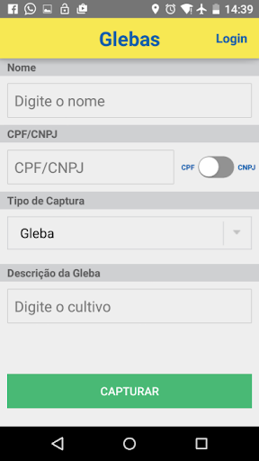
GeoMapa Rural is a cutting-edge application developed by Banco do Brasil SA, designed to provide farmers with a support tool for efficiently capturing coordinates of rural properties. This innovative solution aids in securing loans from BB by expediting the credit decision process.
Key Features:
- Effortlessly capture latitude and longitude coordinates of rural properties
- Two operational modes: Auto Capture and Manual Capture
- Save data without the need for authentication
- Login option for individuals and corporations
- Web platform for viewing and printing polygons with coordinates
- Upload .gpx, .kml, and shapefiles in .zip format
Operational Modes:
Auto Capture:
In this mode, users can outline the area, and every 10 seconds, the internal GPS of the device records a point.
Manual Capture:
Users can mark points on-site using the GPS function or a satellite map. This mode requires a network connection and mobile data enabled device.
Download GeoMapa Rural today and experience the convenience of efficiently capturing coordinates essential for loan applications in Banco do Brasil.
Download GeoMapa Rural for FREE on SoftPas
User Reviews for GeoMapa Rural 1
-
for GeoMapa Rural
GeoMapa Rural is a game-changer for farmers. Its Auto Capture feature simplifies area outlining, enhancing loan application efficiency.